
Stanfords
United Kingdom
- Ordesa - Monte Perdido National Park Editorial Alpina 2-Map Set
- Ordesa and Monte Perdido National Park at 1:25,000 in a set of two GPS compatible recreational maps in an extensive and very popular series from Editorial Alpina, providing more detailed coverage of this popular hiking area.Contours are at 10m intervals, with relief shading and vegetation colouring. An overprint highlights waymarked PR hiking... Read more

Stanfords
United Kingdom
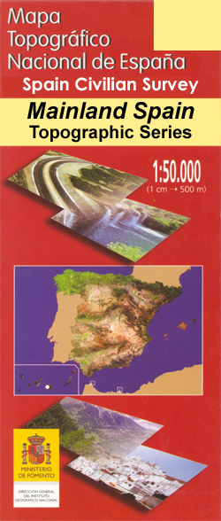
- San Feliu de Guixols CNIG Topo 366
- Topographic coverage of mainland Spain at 1:50,000 in the MTN50 (Mapa Topográfico Nacional) series from the Centro Nacional de Información Geografica, the country’s civilian survey organization. The maps have contours at 20m intervals, enhanced by relief shading, plus colouring and/or graphics to show different types of terrain, vegetation or... Read more

Stanfords
United Kingdom
- Eibar CNIG Topo 63
- Topographic coverage of mainland Spain at 1:50,000 in the MTN50 (Mapa Topográfico Nacional) series from the Centro Nacional de Información Geografica, the country’s civilian survey organization. The maps have contours at 20m intervals, enhanced by relief shading, plus colouring and/or graphics to show different types of terrain, vegetation or... Read more

Stanfords
United Kingdom
- Boltaña CNIG Topo 211
- Topographic coverage of mainland Spain at 1:50,000 in the MTN50 (Mapa Topográfico Nacional) series from the Centro Nacional de Información Geografica, the country’s civilian survey organization. The maps have contours at 20m intervals, enhanced by relief shading, plus colouring and/or graphics to show different types of terrain, vegetation or... Read more

Stanfords
United Kingdom
- A Coruña CNIG Topo 21
- Topographic coverage of mainland Spain at 1:50,000 in the MTN50 (Mapa Topográfico Nacional) series from the Centro Nacional de Información Geografica, the country’s civilian survey organization. The maps have contours at 20m intervals, enhanced by relief shading, plus colouring and/or graphics to show different types of terrain, vegetation or... Read more

Stanfords
United Kingdom
- Algeciras CNIG Topo 1078
- Topographic coverage of mainland Spain at 1:50,000 in the MTN50 (Mapa Topográfico Nacional) series from the Centro Nacional de Información Geografica, the country’s civilian survey organization. The maps have contours at 20m intervals, enhanced by relief shading, plus colouring and/or graphics to show different types of terrain, vegetation or... Read more
Stanfords
United Kingdom
- Bera / Vera de Bidasoa CNIG Topo 65
- Topographic coverage of mainland Spain at 1:50,000 in the MTN50 (Mapa Topográfico Nacional) series from the Centro Nacional de Información Geografica, the country’s civilian survey organization. The maps have contours at 20m intervals, enhanced by relief shading, plus colouring and/or graphics to show different types of terrain, vegetation or... Read more

Stanfords
United Kingdom
- Mataro CNIG Topo 393
- Topographic coverage of mainland Spain at 1:50,000 in the MTN50 (Mapa Topográfico Nacional) series from the Centro Nacional de Información Geografica, the country’s civilian survey organization. The maps have contours at 20m intervals, enhanced by relief shading, plus colouring and/or graphics to show different types of terrain, vegetation or... Read more

Stanfords
United Kingdom
- Los Corrales de Buelna CNIG Topo 58
- Topographic coverage of mainland Spain at 1:50,000 in the MTN50 (Mapa Topográfico Nacional) series from the Centro Nacional de Información Geografica, the country’s civilian survey organization. The maps have contours at 20m intervals, enhanced by relief shading, plus colouring and/or graphics to show different types of terrain, vegetation or... Read more

Stanfords
United Kingdom
- Guitiriz CNIG Topo 46
- Topographic coverage of mainland Spain at 1:50,000 in the MTN50 (Mapa Topográfico Nacional) series from the Centro Nacional de Información Geografica, the country’s civilian survey organization. The maps have contours at 20m intervals, enhanced by relief shading, plus colouring and/or graphics to show different types of terrain, vegetation or... Read more

Stanfords
United Kingdom
- Gergal CNIG Topo 1029
- Topographic coverage of mainland Spain at 1:50,000 in the MTN50 (Mapa Topográfico Nacional) series from the Centro Nacional de Información Geografica, the country’s civilian survey organization. The maps have contours at 20m intervals, enhanced by relief shading, plus colouring and/or graphics to show different types of terrain, vegetation or... Read more

Stanfords
United Kingdom
- Almagro CNIG Topo 785
- Topographic coverage of mainland Spain at 1:50,000 in the MTN50 (Mapa Topográfico Nacional) series from the Centro Nacional de Información Geografica, the country’s civilian survey organization. The maps have contours at 20m intervals, enhanced by relief shading, plus colouring and/or graphics to show different types of terrain, vegetation or... Read more

Stanfords
United Kingdom
- Cariño CNIG Topo 1
- Topographic coverage of mainland Spain at 1:50,000 in the MTN50 (Mapa Topográfico Nacional) series from the Centro Nacional de Información Geografica, the country’s civilian survey organization. The maps have contours at 20m intervals, enhanced by relief shading, plus colouring and/or graphics to show different types of terrain, vegetation or... Read more

Stanfords
United Kingdom
- A Gudiña CNIG Topo 266
- Topographic coverage of mainland Spain at 1:50,000 in the MTN50 (Mapa Topográfico Nacional) series from the Centro Nacional de Información Geografica, the country’s civilian survey organization. The maps have contours at 20m intervals, enhanced by relief shading, plus colouring and/or graphics to show different types of terrain, vegetation or... Read more
Stanfords
United Kingdom
- Banyoles CNIG Topo 295
- Topographic coverage of mainland Spain at 1:50,000 in the MTN50 (Mapa Topográfico Nacional) series from the Centro Nacional de Información Geografica, the country’s civilian survey organization. The maps have contours at 20m intervals, enhanced by relief shading, plus colouring and/or graphics to show different types of terrain, vegetation or... Read more