Stanfords
United Kingdom
- Val Pellice
- Val Pellice area of the Italian Alps presented at 1:25,000 in a series of large, contoured and GPS compatible walking maps from Fraternali Editore, printed on light, waterproof and tear-resistant synthetic paper. Maps in this series have topography shown by contour lines at 5m intervals with relief shading, spot heights, and colouring and/or... Read more

Stanfords
United Kingdom
- Valle Maira l`Escursionista Editore
- Valle Maira, at 1:25,000 on a waterproof and tear-resistant, double-sided, contoured and GPS-compatible map from the Istituto Geografico Adriatico with an overprint highlighting numerous local and long-distance hiking trails, including the GTA (Grande Traversata delle Alpi). The map shows various types of accommodation (huts and refuges, B&Bs,... Read more

Stanfords
United Kingdom
- Gran Paradiso - Valle d`Aosta - Valle del`Orco Kompass 86
- Gran Paradiso - Valle d`Aosta area of the Italian Alps on a GPS compatible hiking and recreational map at 1:50,000 from Kompass on durable, waterproof and tear-resistant synthetic paper. Coverage includes Cogne, Valgrisenche, Val di Rhèmes, Valsavarenche, Valle Soana and Val dell’Orco, as well as a section of the GTA – Grande Travesata delle... Read more

Stanfords
United Kingdom
- Val Brembana - Valsassina - Le Grigne: Lecco - Bergamo 50K IGC Map No. 22
- Val Brembana - Valsassina - Le Grigne area including Lecco and Bergamo in a series contoured hiking maps at 1:50,000 with local trails, long-distance footpaths, mountain accommodation, etc. from the Turin based Istituto Geografico Centrale.Maps in this series have contours at 50m intervals, enhanced by shading and graphic relief. An overprint... Read more

Stanfords
United Kingdom

Stanfords
United Kingdom
- Lanzo - Viù - Chialamberto - Locana 25K IGC Map No. 110
- Lanzo - Viù - Chialamberto - Locana – Cirié – Basse Valli di Lanzo area at 1:25,000 in a series of contoured, GPS compatible walking maps from the Turin based Istituto Geografico Centrale, highlighting hiking trails including long-distance routes, ski routes and alpine accommodation. Maps in this series have contours at 25m intervals, enhanced... Read more

Stanfords
United Kingdom
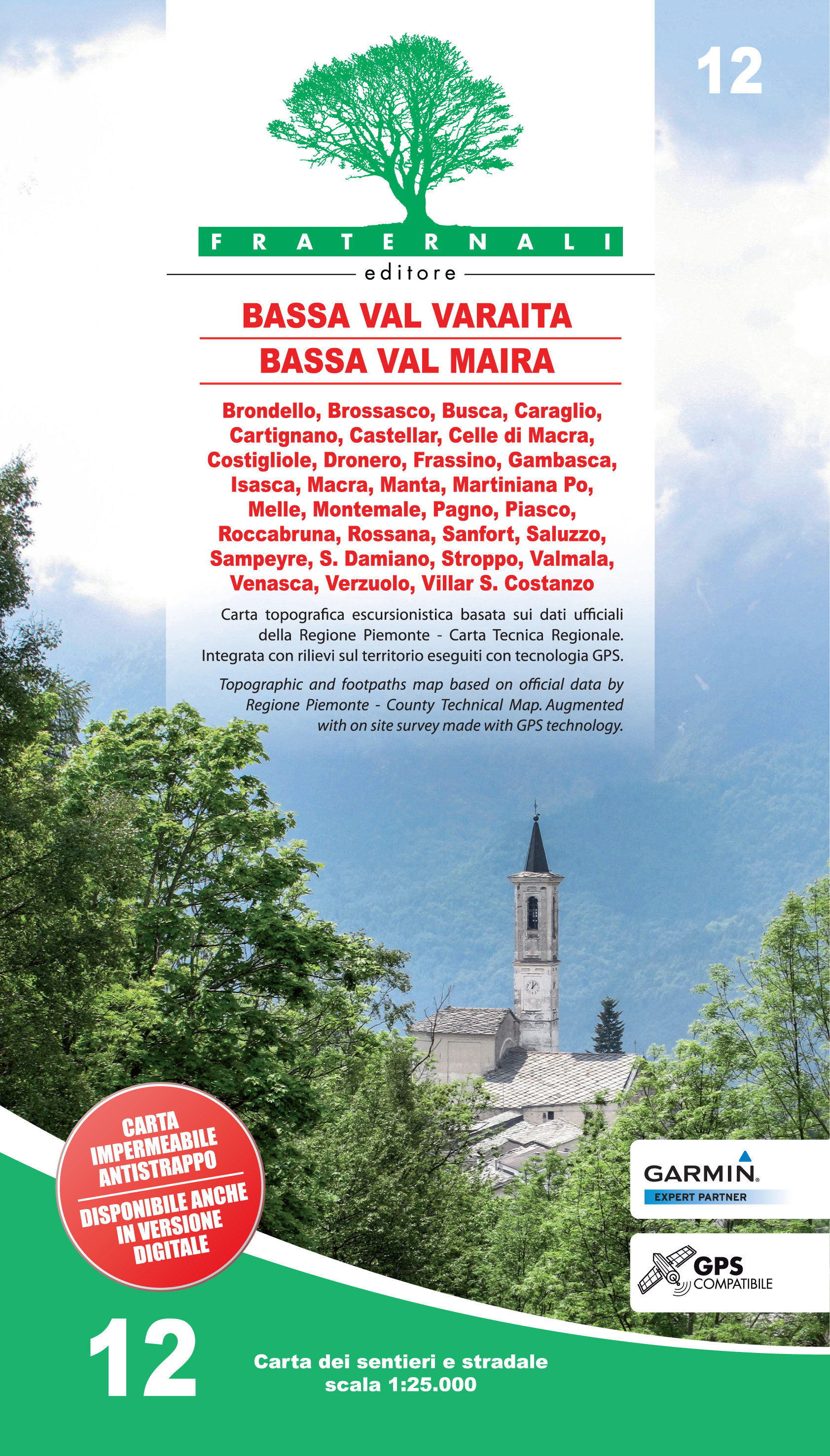
- Bassa Valle Varaita - Bassa Valle Maira Fraternali Editore 12
- Bassa Valle Varaita - Bassa Valle Maira in the Italian Alps presented at 1:25,000 in a series of large, contoured and GPS compatible walking maps from Fraternali Editore, printed on light, waterproof and tear-resistant synthetic paper. Maps in this series have topography shown by contour lines at 5m intervals with relief shading, spot heights,... Read more
De Zwerver
Netherlands
- Wandelkaart 12 Bassa Val Varaita - Bassa Val Maira | Fraternali Editore
- Gebied: Brondello, Brossasco, Busca, Caraglio, Cartignano, Castellar, Celle di Macra, Costigliole, Dronero, Frassino, Gambasca, Isasca, Macra, Manta, Martiniana Po, Melle, Montemale, Pagno, Piasco, Roccabruna, Rossana, Sanfront, Saluzzo, Sampeyre, S. Damiano, Stroppo, Valmala, Venasca, Verzuolo, Villar S. Costanzo Een uitstekende wandelkaart... Read more

Stanfords
United Kingdom
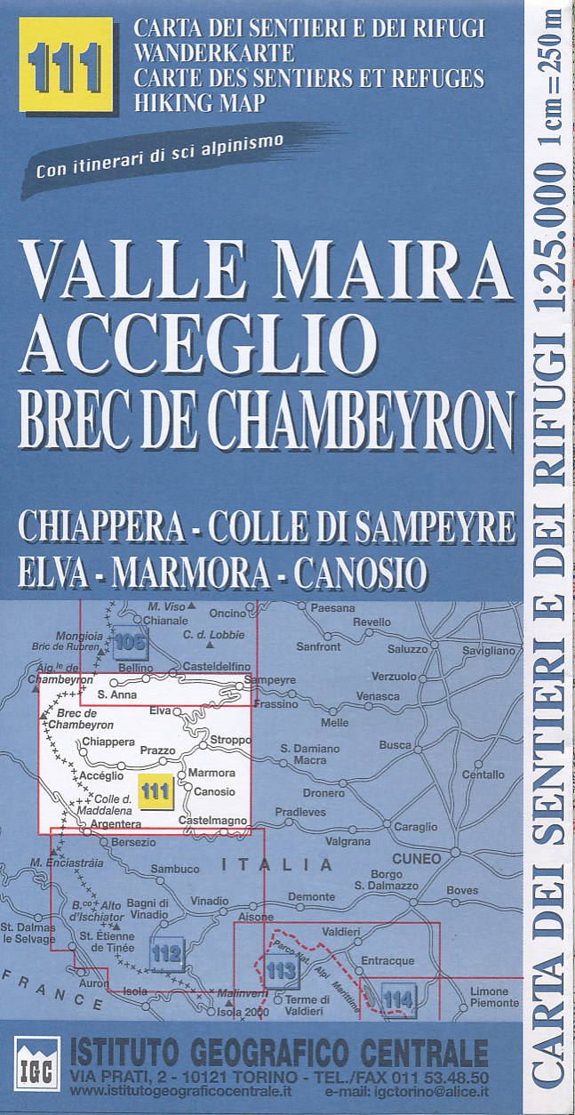
- Valle Maira - Acceglio 25K IGC Map No. 111
- Valle Maira - Acceglio area at 1:25,000 in a series of contoured, GPS compatible walking maps from the Turin based Istituto Geografico Centrale, highlighting hiking trails including long-distance routes, ski routes and alpine accommodation. Maps in this series have contours at 25m intervals, enhanced by shading and graphic relief for very clear... Read more
Stanfords
United Kingdom
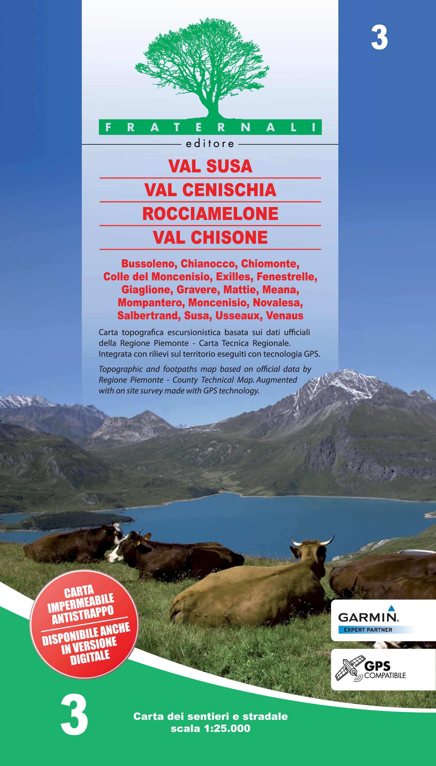
- Val Susa - Val Cenischia - Rocciamelone - Val Chisone
- Val Susa - Val Cenischia - Rocciamelone - Val Chisone area of the Italian Alps presented at 1:25,000 in a series of large, contoured and GPS compatible walking maps from Fraternali Editore, printed on light, waterproof and tear-resistant synthetic paper. Maps in this series have topography shown by contour lines at 5m intervals with relief... Read more
De Zwerver
Netherlands
- Wandelkaart 03 Val Susa - Val Cenischia | Fraternali Editore
- Val Susa - Val Cenischia - Rocciamelone - Val Chisone area of the Italian Alps presented at 1:25,000 in a series of large, contoured and GPS compatible walking maps from Fraternali Editore, printed on light, waterproof and tear-resistant synthetic paper. Maps in this series have topography shown by contour lines at 5m intervals with relief... Read more

Stanfords
United Kingdom
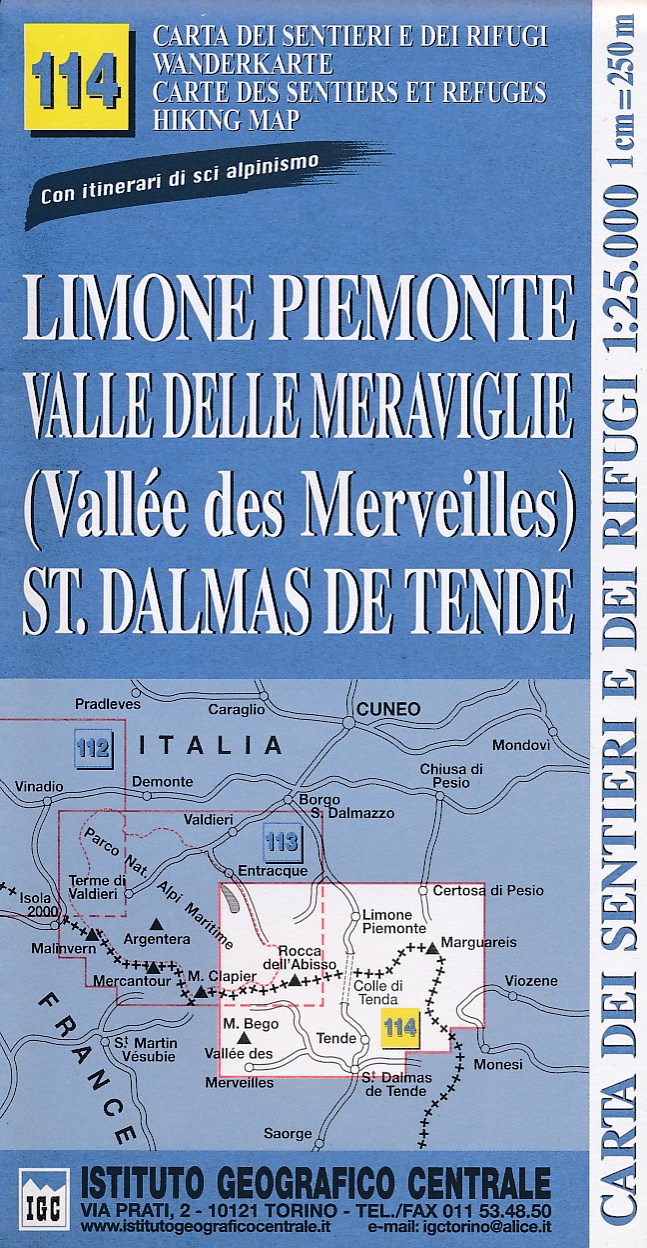
- Limone Piemonte - Vallée des Merveilles 25K IGC Map No. 114
- Limone Piemonte - Vallée des Merveilles area at 1:25,000 in a series of contoured, GPS compatible walking maps from the Turin based Istituto Geografico Centrale, highlighting hiking trails including long-distance routes, ski routes and alpine accommodation. Maps in this series have contours at 25m intervals, enhanced by shading and graphic... Read more

Stanfords
United Kingdom
- Monviso IGC 6
- Monviso / Monte Viso cross-border area with coverage from Châteaux Queyras to Sampeyre and from the Grand Queyron to the Aiguille de Chambeyron in a series contoured hiking maps at 1:50,000 with local trails, long-distance footpaths, mountain accommodation, etc. from the Turin based Istituto Geografico Centrale.Maps in this series have contours... Read more

De Zwerver
Netherlands
- Wandelkaart 06 Monviso | IGC - Istituto Geografico Centrale
- Monviso / Monte Viso cross-border area with coverage from Châteaux Queyras to Sampeyre and from the Grand Queyron to the Aiguille de Chambeyron in a series contoured hiking maps at 1:50,000 with local trails, long-distance footpaths, mountain accommodation, etc. from the Turin based Istituto Geografico Centrale.Maps in this series have contours... Read more

Stanfords
United Kingdom
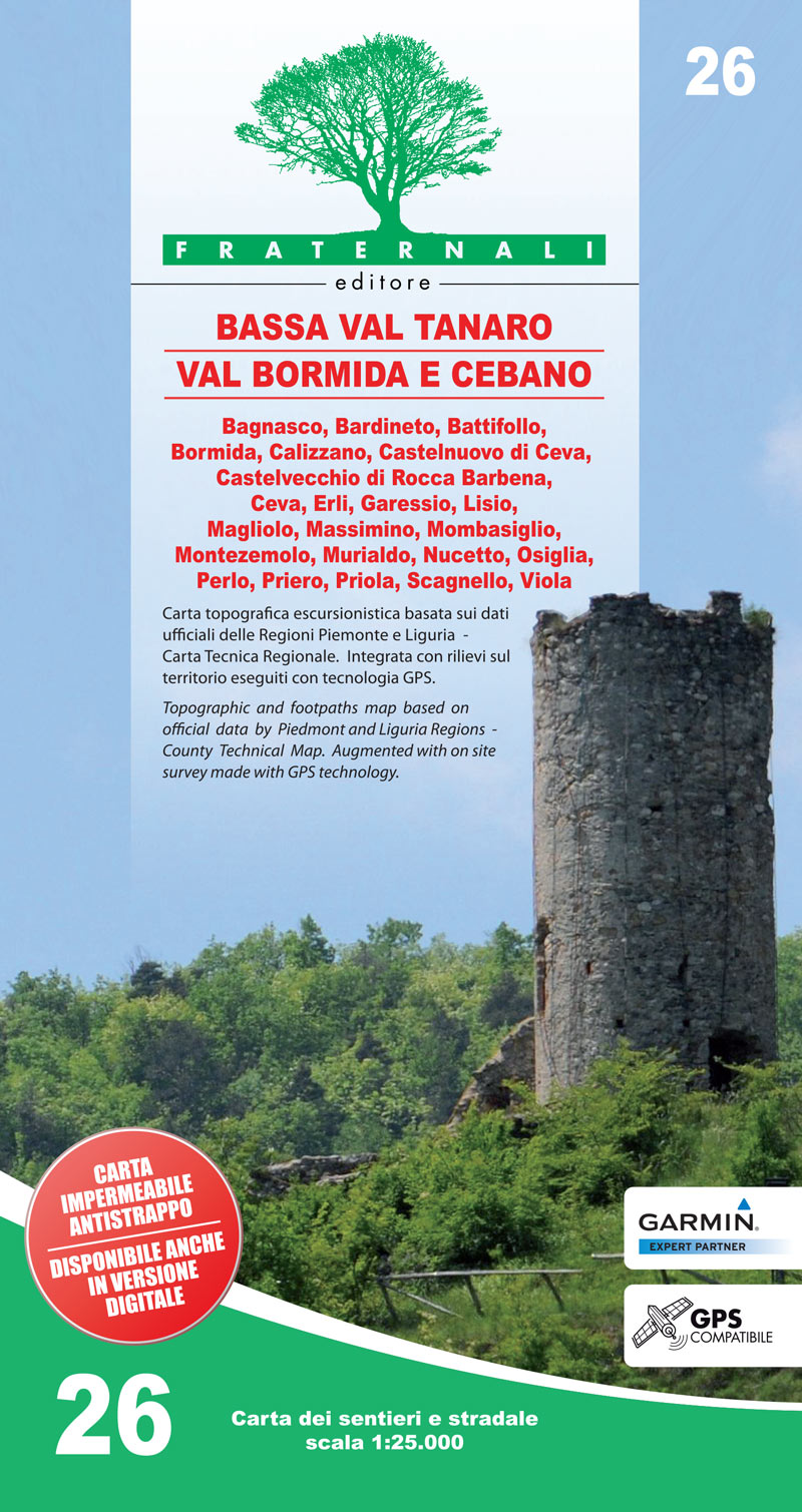
- Bassa Val Tanaro - Val Bormida e Cebano
- Val Vermenagna - Valle Pesio - Alta Valle Ellero area of the Italian Alps presented at 1:25,000 in a series of large, contoured and GPS compatible walking maps from Fraternali Editore, printed on light, waterproof and tear-resistant synthetic paper. Maps in this series have topography shown by contour lines at 5m intervals with relief shading,... Read more

Stanfords
United Kingdom
- Monte Rosa - Alagna - Macugnaga 50K IGC Map No. 10
- Monte Rosa - Alagna - Macugnaga in a series contoured hiking maps at 1:50,000 with local trails, long-distance footpaths, mountain accommodation, etc. from the Turin based Istituto Geografico Centrale.Maps in this series have contours at 50m intervals, enhanced by shading and graphic relief. An overprint highlights local footpaths and... Read more
Stanfords
United Kingdom
De Zwerver
Netherlands
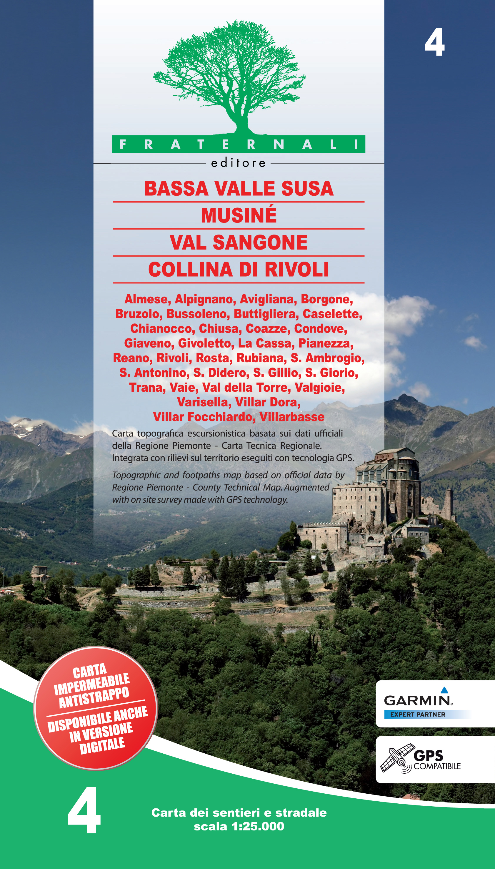
- Wandelkaart 04 Bassa Valle Susa, Musinè, Val Sangone, Collina di Rivoli | Fraternali Editore
- Gebied: Bussoleno, San Giorio, Chianocco, Bruzolo, Condove, San Didero, Borgone, Villar Dora, Villar Focchiardo, S. Antonino, Vaie, Chiusa , S. Ambrogio, Almese, Rubiana, Caselette, Valgioie, Coazze, Giaveno, Avigliana, Buttigliera , Rosta, Reano, Villarbasse, Trana, Val della Torre Een uitstekende wandelkaart van de westkant van Italie waar... Read more

Stanfords
United Kingdom
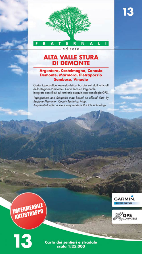
- Alta Valle Stura di Demonte
- Alta Valle Stura di Demonte in the Italian Alps presented at 1:25,000 in a series of large, contoured and GPS compatible walking maps from Fraternali Editore, printed on light, waterproof and tear-resistant synthetic paper. Maps in this series have topography shown by contour lines at 5m intervals with relief shading, spot heights, and... Read more
De Zwerver
Netherlands
- Wandelkaart 13 Alta Valle Stura di Demonte | Fraternali Editore
- Alta Valle Stura di Demonte in the Italian Alps presented at 1:25,000 in a series of large, contoured and GPS compatible walking maps from Fraternali Editore, printed on light, waterproof and tear-resistant synthetic paper. Maps in this series have topography shown by contour lines at 5m intervals with relief shading, spot heights, and... Read more