
Pyrenees
Description

The Pyrenees form the natural border between Spain and france. The mountain range extends from one sea to the other, from the Atlantic to the Mediterranean, always a good excuse for hikers to symbolically cross over and stay away from home two months.
Of course there is a fan group of the Pyrenees versus one of the Alps. The Pyrenees are very different from the Alps alltogether. There are no large lakes, but many high situated small ones. There are almost no passings over the Pyrenees from France into Spain. The famous exceptions - St Jean-Pied-de-Port and Col de Somport - are used by the Way of St. James, Camino de Santiago.
There are plenty of good hikes, among them the GR10, the Haute Randonnée Pyrénéenne, and - on the Spanish side, the GR11.
Map

Trails in this region
- Camino AragonésGPX
- Camino de BaztanGPX
- Camino de GironaGPX
- Camino FrancésGPX
- Carros de FocGPX
- E3GPX
- E4GPX
- E7GPX
- GR10 - Traversée des PyrénéesGPX
- GR101GPX
- GR107 - El Camí dels Bons HomesGPX
- GR11 Sendero PirenaicoGPX
- GR36 - Traversée du PérigordGPX
- GR65 - Via PodiensisGPX
- GR7GPX
- GR78 - Sentier de PiémontGPX
- GR8GPX
- GR83 - Camí del Nord o del CanigóGPX
- GR86GPX
- HRP - Haute Randonnée PyrénéenneGPX
- Sentier CathareGPX
- Tour du LarzacGPX
- Voie de Lourdes
- Voie du PiémontGPX
Links
Facts
Reports
Guides and maps
Lodging
Organisations
Tour operators
GPS
Other
Books

United Kingdom
- A Cyclist`s Guide to the Pyrenees
- Where do you turn when you want to ride in the mountains, to follow in the wheeltracks of professional racers by climbing the famous passes of the Tour de France? There are several books and websites that highlight these renowned ascents, detailing their location, length and every little change in gradient. But how do you go about finding a... Read more

United Kingdom
2011
- GRP: Monts et Lacs du Lévézou FFRP Topo-guide No. 1201
- Monts et Lacs du Lévézou, FFRP topo-guide ref. no. 1201, covering two hiking circuits in the Massif Central near Rodez and Millau; in all 214kms of routes. Current edition of this title was published in March 2011.ABOUT THE FFRP (Fédération française de la randonnée pédestre) TOPOGUIDES: published in a handy A5 paperback format, the guides are... Read more

United Kingdom
2012
- GR93/GR94 Tours dans les Hautes-Alpes FFRP Topo-guide No. 940
- Tours dans les Hautes-Alpes, FFRP topoguide Ref. no. 940, covering 691km of hiking routes along the GR93 and GR94 in the French Alps west of Gap. The routes can be combined, as required, into shorter or longer circuits. Current edition of this title was published in June 2012.ABOUT THE FFRP (Fédération française de la randonnée pédestre)... Read more
United Kingdom
2018
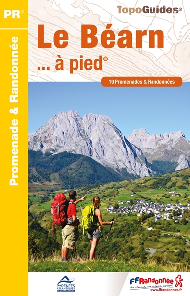
- Le Béarn à pied P641
- Le Béarn à pied, FFRP topo-guide Ref. No. P641, with 20 day walks of varying length and difficulty in the Pyrenees and their foothills between Pau, Pic du Midi d`Ossau and Col du Somport. Each walk is presented on a separate colour extract from IGN’s topographic survey of France at 1:25,000, with its description cross-referenced to the map.... Read more

United Kingdom
2020
- Les Abers - le Chemin de Phares GR34/GR34F
- Les Abers - le chemin de phares, FFRP topoguide Ref. no. 347, covering the coastal route in north-western Brittany between Morlaix, Brest, and le Fau, plus 4 walks on the Ile d`Ouessant. Current edition of this title was published in September 2017.Between Morlaix and Brest, where the sea has dug deep furrows in the land. More than 20 days of... Read more

United Kingdom
2019
- Les Hautes-Pyrénées à pied
- Les Hautes-Pyrénées à pied, FFRP topo-guide Ref. No. D065, with 45 day walks of varying length and difficulty in the heart of the French Pyrenees, from north of Tarbes to the Pyrenees National Park near Gavarnie. Current edition of this title was published in February 2016.To see the list of other FFRP guides with day walks please click on the... Read more

United Kingdom
2019
- Du Léman à la Vanoise - par le Mont Blanc et le Beaufortain GR5
- The first, 206-km long Alpine section of the GR5 from Lake Geneva, past Mont Blanc and across the Col de la Croix-du-Bonhomme, to Landry north of the Vanoise Massif, FFRP topo-guide ref. no. 504, with colour maps from the IGN TOP25 series at 1:25,000. Also included is a tour of the Dents du Midi. Current edition of this title was published in... Read more

United Kingdom
2017
- Chemins de St. Jacques: Toulouse - Jaca - Lourdes GR653/GR101/GR78
- The last stretch of the Toulouse route before reaching Spain and the Camino Frances.Chemins de St. Jacques: Toulouse - Jaca, FFRP topoguide Ref. No. 6534, covering one of the southern routes of the Way of St. James in France: from Toulouse along the GR 653, with variants through Pau or Tarbes, across Col du Somport to Jaca in the Spanish... Read more

United Kingdom
2015
- GR9/GR96/GRP: Tours et Traversées de Chartreuse FFRP Topo-guide No. 903
- Tours et Traversées de Chartreuse, FFRP topoguide Ref. no. 903, covering 385kms of routes along the GR9 and GR96 in the northern part of the French Alps between Culoz, Chambéry and Grenoble. Current edition of this title was published in May 2015.ABOUT THE FFRP (Fédération française de la randonnée pédestre) TOPOGUIDES: published in a handy A5... Read more

United Kingdom
2016
- St-Jacques-de-Compostelle - Puy-en-Velay to Moissac GR65-1 IGN 89020
- Chemin de St-Jacques - the Way of St James in France along the GR65 between Le Puy-en-Velay and Moissac presented at 1:100,000 on a double-sided, waterproof and tear-resistant map from IGN with cartography from their highly popular TOP100 series. The route is prominently highlighted on contoured mapping and annotated with hiking distances.... Read more
United Kingdom
2018
- Val d`Azun à pied ST10
- Val d`Azun à pied, FFRP topo-guide Ref. No. ST10, with 18 day walks of varying length and difficulty in the French Pyrenees south-west of Argelès-Gazost, plus a tour which includes part of the GR10 long-distance footpaths. Each walk is presented on a separate colour extract from IGN’s topographic survey of France at 1:25,000 and/or 1:50,000,... Read more
United Kingdom
2020
- La Traversee der Alpes La Vanoise - PN de la Vanoise GR5/GR55
- 15 days in altitude from the Tarentaise to Modane, heart of the Maurienne. Description also of Via Alpina.La Vanoise (including Parc National de la Vanoise), FFRP topoguide Ref. no. 530, covering the second section of the GR5 in the French Alps between Landry and Modane, its lower variant on the GR5E along the river Arc, plus the traverse of... Read more

United Kingdom
- Taga - Serra Cavallera Editorial Alpina
- Taga – Serra Cavalara area in the eastern part of the Spanish Pyrenees on a contoured and GPS compatible map at 1:25,000 from Editorial Alpina, highlighting local and long-distance hiking trails, accommodation facilities, etc.The map has contour lines at 10m intervals enhanced by relief shading, plus colouring to indicate different types of... Read more

United Kingdom
2019
- Cote d`Emeraude - Les Chemins du Mont-Saint-Michel GR34/GR37
- Côte d`Emeraude: Les Chemins du Mont-St-Michel, FFRP topoguide Ref. no. 345, covering in all 636km of GR routes in western Brittany: the coastal path between Mont-St-Michel, St-Malo and St-Brieuc, plus circuits linking Rennes with the coast. Current edition of this title was published in March 2019 ABOUT THE FFRP (Fédération française de la... Read more
United Kingdom
- St-Lary-Soulan et la Vallée d`Aure à pied ST07
- Saint-Lary-Soulan et la vallée d`Aure à pied, FFRP topo-guide Ref. No. ST07, with 25 day walks of varying length and difficulty in the French Pyrenees. Each walk is presented on a separate colour extract from IGN’s topographic survey of France at 1:25,000, with its description cross-referenced to the map. Current edition of this title was... Read more
Maps

United Kingdom
2016
- Le Languedoc-Roussillon à pied FFRP Topo-guide No. RE13
- Le Languedoc-Roussillon à pied, FFRP topo-guide Ref. No. RE13, with 50 day walks in the some of the most visited departments in France: Lozère, Gard, Hérault, Aude and Pyrénées Orientales which include Mende, Alès, Nîmes, Montpellier, Béziers, Narbonne, Carcassonne and Perpignan. Each day walk is presented on a separate colour extract from... Read more

United Kingdom
- Pyrenees East - Barcelona - Costa Brava 500K CNIG Regional Map No. 4
- The eastern part of Spanish Pyrenees, with coverage extending along the Mediterranean coast beyond Barcelona to Tarragona, at 1:500,000 in a series of regional road maps from the country’s civilian survey organization IGN-CNIG (Instituto Geográfico Nacional - Centro Nacional de Información Geográfica), vividly presenting the topography by... Read more

United Kingdom
- Vall de Barravés - Ribagorça Editorial Alpina
- Val de Barravés - Ribagorça at 1:25,000 in an extensive and very popular series of walking maps from Editorial Alpina covering the Pyrenees, Catalonia and other selected hiking areas in Spain, including Picos de Europa, Sierra Nevada and parts of Andalucía, Majorca, etc.Scales of maps in this series vary from 1:50,000 to 1:10,000, with the... Read more

United Kingdom
- Costabona - Alta Val de Ter Editorial Alpina
- Costabona - Alta Val de Ter area of the Catalan Pyrenees on a contoured and GPS compatible map at 1:25,000 from Editorial Alpina, highlighting hiking trails, campsites and refuges, etc. Topography is shown by contours at 10m intervals with relief shading and numerous spot heights, plus colouring for woodlands, brushwood, meadows and farmland.... Read more

United Kingdom
- Ordesa - Monte Perdido National Park Editorial Alpina 2-Map Set
- Ordesa and Monte Perdido National Park at 1:25,000 in a set of two GPS compatible recreational maps in an extensive and very popular series from Editorial Alpina, providing more detailed coverage of this popular hiking area.Contours are at 10m intervals, with relief shading and vegetation colouring. An overprint highlights waymarked PR hiking... Read more

United Kingdom
- Garrotxa - Zona Volcanica Editorial Alpina
- Garrotxa Volcanic Zone Natural Park near Olot in the Catalan Pyrenees on a contoured and GPS-compatible map at 1:25,000 from Editoral Alpina, highlighting local and long-distance hiking trails, etc, plus a booklet with 26 pages in English providing descriptions of 11 recommended local walks, etc.The map has contours at 10m intervals with relief... Read more

United Kingdom
- Val d`Aran by UTMB Editorial Alpina Trail running race Map
- Val d`Aran in an extensive and very popular series of walking maps from Editorial Alpina covering the Pyrenees, Catalonia and other selected hiking areas in Spain, including Picos de Europa, Sierra Nevada and parts of Andalucía, Majorca, etc. Scales vary from 1:50,000 to 1:10,000, with the majority of the titles at 1:25,000. The maps have... Read more

United Kingdom
- Grande Traversée Ariège-Pyrénées à VTT: Ax-les-Thermes – Lacave (223km)
- Grande Traversée Ariège-Pyrénées à VTT: Ax-les-Thermes - Lacave (223km) from Chamina covers a 223km mountain bike route in the central part of the French Pyrenees, shown on 1:50,000 topographic survey mapping from the IGN with additional tourist information.The title is presented as a boxed set of 15 loose pages plus a booklet with practical... Read more
United Kingdom
2019
- Tours et Traversées du Vercors - du Diois et les Baronnies GR9/GR91
- Tours et Traversées dans Vercors, le Diois et les Baronnies, FFRP topo-guide Ref. No. 904, covering in all over 1000 km of routes and circuits along the GR9, GR91, GR93, GR95, GR429 and GRs de Pays between Grenoble, Die and Brantes in Provence north of Mt Ventoux. Topographic mapping from the IGN is accompanied by detailed route descriptions,... Read more

United Kingdom
- Font-Romeu - Capcir IGN WATERPROOF 2249ETR
- Topographic survey of France at 1:25,000 in IGN`s excellent TOP25 / Série Bleue series. All the maps are GPS compatible, with a 1km UTM grid plus latitude and longitude lines at 5’ intervals. Contours are at 5m intervals except for mountainous areas where the maps have contours at 10m intervals, vividly enhanced by hill shading and graphics for... Read more

United Kingdom
- Massat - Pic des Trois Seigneurs - PNR ses Pyrenees-Ariegeoises IGN 2047ET
- Topographic survey of France at 1:25,000 in IGN`s excellent TOP25 / Série Bleue series. All the maps are GPS compatible, with a 1km UTM grid plus latitude and longitude lines at 5’ intervals. Contours are at 5m intervals except for mountainous areas where the maps have contours at 10m intervals, vividly enhanced by hill shading and graphics for... Read more

United Kingdom
- Bourg-Madame - Pic Carlit - Col de Puymorens IGN 2249OT
- Topographic survey of France at 1:25,000 in IGN`s excellent TOP25 / Série Bleue series. All the maps are GPS compatible, with a 1km UTM grid plus latitude and longitude lines at 5’ intervals. Contours are at 5m intervals except for mountainous areas where the maps have contours at 10m intervals, vividly enhanced by hill shading and graphics for... Read more

United Kingdom
- Saint-Bertrand-de-Comminges IGN 1847OT
- Topographic survey of France at 1:25,000 in IGN`s excellent TOP25 / Série Bleue series. All the maps are GPS compatible, with a 1km UTM grid plus latitude and longitude lines at 5’ intervals. Contours are at 5m intervals except for mountainous areas where the maps have contours at 10m intervals, vividly enhanced by hill shading and graphics for... Read more

United Kingdom
- Aragón Autonomous Region 300K CNIG Physical Road Map
- Aragón Autonomous Region of Spain at 1:300,000 on a large physical map from the IGN/CNIG - country’s civilian survey organization providing an excellent picture of the region’s topography, from the peaks of the highest part of the Pyrenees, across the valley of the Ebro, to the sierras of southern Teruel province. Icons prominently highlight... Read more

United Kingdom
- Tour of the Canigó Hiking Circuit
- A 64-km long tour of Canigó (Canigou), the highest mountain in the eastern Pyrenees, presented by Editorial Alpina on a contoured, GPS compatible map at 1:25,000, with a booklet providing descriptions of its recommended stages.The map has contours at 20m intervals, enhanced by relief shading. The tour which follows sections of the GR10, the HRP... Read more