
West Virginia
Description
West Virginia is a forested state, good for hiking. The Allegheny Trail largely lies in West Virginia (270 out of 330 miles). The Tuscarora Trail has some 66 miles in this state.
The state also has a share of the American Discovery Trail, the Eastern Continental Trail and the Great Eastern Trail.
By far the largest wilderness in West Virginia is the Monongahela National Forest. Second best would be the George Washington National Forest, in the east, bordering on Virginia.
Map

Trails in this state
Links
Facts
Reports
Guides and maps
Lodging
Organisations
Tour operators
GPS
Other
Books

Stanfords
United Kingdom
United Kingdom
- A Horse Walks into a Bar
- The setting is a comedy club in a small Israeli town. An audience that has come expecting an evening of amusement instead sees a comedian falling apart on stage; an act of disintegration, a man crumbling, as a matter of choice, before their eyes. They could get up and leave, or boo and whistle and drive him from the stage, if they were not so... Read more

Stanfords
United Kingdom
United Kingdom
- Blur Ridge Parkway: Northern Section
- The northern section of the Blue Ridge Parkway and the surrounding area of the Appalachian Mountains on a double-sided map at 1:135,000 approx. from Outdoor Paths Publishing highlighting facilities along the route. The map covers the first part of the Parkway, from Milepost 0 to 123.Topography of the area is shown by relief shading based on the... Read more

Stanfords
United Kingdom
United Kingdom
- The Wild Atlantic Way Route Atlas - Ireland West
- The Wild Atlantic Way is a 25,000 kilometre coastal route along Ireland’s Atlantic coast that stretches between the southerly point of Kinsale, County Cork up to Derry. This route is favoured by many in its entirety or broken down into more manageable, day trip sections. This Xploreit handy sized spiral bound route atlas contains 30 easy-to-use... Read more
Stanfords
United Kingdom
United Kingdom
- Blur Ridge Parkway Southern Section
- The northern section of the Blue Ridge Parkway and the surrounding area of the Appalachian Mountains on a double-sided map at 1:135,000 approx. from Outdoor Paths Publishing highlighting facilities along the route. The map covers the first part of the Parkway, from Milepost 0 to 123.Topography of the area is shown by relief shading based on the... Read more

Stanfords
United Kingdom
United Kingdom
- World Awesome Maps Hiking Wall Map
- Illustrated world map with the best hiking trails across the globe. Over 300 trails, from short glacier walks like the Perito Moreno Glacier Walk in Argentina to long-distance treks like the Appalachian Trail and Bibbulmun Track in Australia to lesser known remote trails like the Huahuash Circuit in Peru.- High quality offset print on... Read more

Stanfords
United Kingdom
United Kingdom
- Waldviertel North - Gmund - Heidenreichstein - Waidhofen & Raabs a.d.T. - Trebon F&B WK075
- Waldviertel North - Gmünd - Heidenreichstein - Waidhofen a.d.T. - Raabs a.d.T. – Trebon area of eastern Austria presented at 1:50,000 in a series of contoured and GPS compatible outdoor leisure map from Freytag & Berndt with hiking and cycling routes, mountain huts, campsites and youth hostels, local bus stops, plus other tourist information.To... Read more

The Book Depository
United Kingdom
United Kingdom
- A Walk for Sunshine
- A 2,160-mile Expedition for Charity on the Appalachian Trail Read more


The Book Depository
United Kingdom
2022
United Kingdom
2022
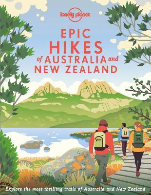
- Lonely Planet Epic Hikes of Australia & New Zealand
- Lace up your hiking boots for the next in Lonely Planet`s highly successful Epic Hikes series, this time exploring 50 of Australia and New Zealand`s most rewarding treks and trails. From the Routeburn Track in New Zealand`s South Island to the Cape to Cape walk in Western Australia`s Leeuwin-Naturaliste National Park, we cover a huge variety of... Read more
- Also available from:
- De Zwerver, Netherlands
De Zwerver
Netherlands
2022
Netherlands
2022
- Wandelgids Hikes of Australia and New Zealand | Lonely Planet
- Lace up your hiking boots for the next in Lonely Planet`s highly successful Epic Hikes series, this time exploring 50 of Australia and New Zealand`s most rewarding treks and trails. From the Routeburn Track in New Zealand`s South Island to the Cape to Cape walk in Western Australia`s Leeuwin-Naturaliste National Park, we cover a huge variety of... Read more

The Book Depository
United Kingdom
United Kingdom
- Five Million Steps
- Faith Adventures along the Appalachian Trail Read more

The Book Depository
United Kingdom
United Kingdom
- Grandma Gatewood's Walk
- The Inspiring Story of the Woman Who Saved the Appalachian Trail Read more

The Book Depository
United Kingdom
United Kingdom
- Footprints on the Mountains
- Hiking the Appalachian Trail from Georgia to Maine Read more

The Book Depository
United Kingdom
United Kingdom
- Suffolk Year Round Walks
- Suffolk, with its glorious coastline, charming villages and medieval towns, is a walker`s delight. The twenty circular walks in this book vary in length from 3 to 6 miles and are enjoyable all year round. The author has divided the routes into seasons to show each at its very best. In spring, the fen meadows and ancient woodland near Agner Fen... Read more

The Book Depository
United Kingdom
United Kingdom
- A Child's Walk in the Wilderness
- An 8-Year-Old Boy and His Father Take on the Appalachian Trail Read more
Maps

Stanfords
United Kingdom
United Kingdom
- Damodar Kunda
- Damodar Kunda, sheet no. 2984-13, in the topographic survey of Nepal at 1:50,000 published by the Nepali Government in the late 1990s and early 2000s and produced from remote sensing data by Finnish cartographers as part of that country’s international aid program. The maps cover 15’ x 15’ quadrangles.IMPORTANT – PLEASE NOTE BEFORE ORDERING:... Read more
Stanfords
United Kingdom
United Kingdom
- Sabha Khola - Chainpur
- Sabha Khola - Chainpur, sheet no. 2787-10, in the topographic survey of Nepal at 1:50,000 published by the Nepali Government in the late 1990s and early 2000s and produced from remote sensing data by Finnish cartographers as part of that country’s international aid program. The maps cover 15’ x 15’ quadrangles.IMPORTANT – PLEASE NOTE BEFORE... Read more
Stanfords
United Kingdom
United Kingdom
- Chala Bhanjyan
- Chala Bhanjyan, sheet no. 2983-06, in the topographic survey of Nepal at 1:50,000 published by the Nepali Government in the late 1990s and early 2000s and produced from remote sensing data by Finnish cartographers as part of that country’s international aid program. The maps cover 15’ x 15’ quadrangles.IMPORTANT – PLEASE NOTE BEFORE ORDERING:... Read more
Stanfords
United Kingdom
United Kingdom
- Likhu Khola - Those
- Likhu Khola - Those, sheet no. 2786-06, in the topographic survey of Nepal at 1:50,000 published by the Nepali Government in the late 1990s and early 2000s and produced from remote sensing data by Finnish cartographers as part of that country’s international aid program. The maps cover 15’ x 15’ quadrangles.IMPORTANT – PLEASE NOTE BEFORE... Read more
Stanfords
United Kingdom
United Kingdom
- Dunai
- Dunai, sheet no. 2882-04, in the topographic survey of Nepal at 1:50,000 published by the Nepali Government in the late 1990s and early 2000s and produced from remote sensing data by Finnish cartographers as part of that country’s international aid program. The maps cover 15’ x 15’ quadrangles.IMPORTANT – PLEASE NOTE BEFORE ORDERING:... Read more
Stanfords
United Kingdom
United Kingdom
- Lower Dudh Kosi - Okhaldhunga
- Lower Dudh Kosi - Okhaldhunga, sheet no. 2786-11, in the topographic survey of Nepal at 1:50,000 published by the Nepali Government in the late 1990s and early 2000s and produced from remote sensing data by Finnish cartographers as part of that country’s international aid program. The maps cover 15’ x 15’ quadrangles.IMPORTANT – PLEASE NOTE... Read more
Stanfords
United Kingdom
United Kingdom
- Khin
- Khin, sheet no. 2981-12, in the topographic survey of Nepal at 1:50,000 published by the Nepali Government in the late 1990s and early 2000s and produced from remote sensing data by Finnish cartographers as part of that country’s international aid program. The maps cover 15’ x 15’ quadrangles.IMPORTANT – PLEASE NOTE BEFORE ORDERING:... Read more
Stanfords
United Kingdom
United Kingdom
- Dorle Pahad
- Dorle Pahad, sheet no. 2885-16, in the topographic survey of Nepal at 1:50,000 published by the Nepali Government in the late 1990s and early 2000s and produced from remote sensing data by Finnish cartographers as part of that country’s international aid program. The maps cover 15’ x 15’ quadrangles.IMPORTANT – PLEASE NOTE BEFORE ORDERING:... Read more
Stanfords
United Kingdom
United Kingdom
- Namrun
- Namrun, sheet no. 2884-08, in the topographic survey of Nepal at 1:50,000 published by the Nepali Government in the late 1990s and early 2000s and produced from remote sensing data by Finnish cartographers as part of that country’s international aid program. The maps cover 15’ x 15’ quadrangles.IMPORTANT – PLEASE NOTE BEFORE ORDERING:... Read more
Stanfords
United Kingdom
United Kingdom
- Khiratadi (114) (2980 08)
- Khiratadi, sheet no. 2980-08, in the topographic survey of Nepal at 1:50,000 published by the Nepali Government in the late 1990s and early 2000s and produced from remote sensing data by Finnish cartographers as part of that country’s international aid program. The maps cover 15’ x 15’ quadrangles.IMPORTANT – PLEASE NOTE BEFORE ORDERING:... Read more

Stanfords
United Kingdom
United Kingdom
- Barcelona High 5 Edition Street Plan
- The first water-resistant “Comfort Map“ with direct access to useful additional information from the InternetBarcelona in a scale of 1:20,000 including detailed presentation of the old town in a scale of 1:11,000 presented on a practical map; inclusive of the High 5 Edition app technology for calling up additional travel information and many... Read more

Stanfords
United Kingdom
United Kingdom
- Cycling the Canal de la Garonne: From Bordeaux to Toulouse
- This guidebook presents a cycle ride along the Canal de la Garonne in the south of France. The 290km route is covered in 7 stages from bustling Bordeaux to the splendid rose city of Toulouse, with a 135km excursion from to Lacanau on the Atlantic coast. Optional side trips explore the countryside and historical towns and villages, including... Read more
Stanfords
United Kingdom
United Kingdom
- Lamjun Himal
- Lamjun Himal, sheet no. 2884-09, in the topographic survey of Nepal at 1:50,000 published by the Nepali Government in the late 1990s and early 2000s and produced from remote sensing data by Finnish cartographers as part of that country’s international aid program. The maps cover 15’ x 15’ quadrangles.IMPORTANT – PLEASE NOTE BEFORE ORDERING:... Read more
Stanfords
United Kingdom
United Kingdom
- Taplejung
- Taplejung, sheet no. 2787-11, in the topographic survey of Nepal at 1:50,000 published by the Nepali Government in the late 1990s and early 2000s and produced from remote sensing data by Finnish cartographers as part of that country’s international aid program. The maps cover 15’ x 15’ quadrangles.IMPORTANT – PLEASE NOTE BEFORE ORDERING:... Read more
Stanfords
United Kingdom
United Kingdom
- Tinje
- Tinje, sheet no. 2983-10, in the topographic survey of Nepal at 1:50,000 published by the Nepali Government in the late 1990s and early 2000s and produced from remote sensing data by Finnish cartographers as part of that country’s international aid program. The maps cover 15’ x 15’ quadrangles.IMPORTANT – PLEASE NOTE BEFORE ORDERING:... Read more