
World
Description
Links
Facts
Reports
Guides and maps
Lodging
Organisations
Tour operators
GPS
Other
Books


The Book Depository
United Kingdom
United Kingdom
- Wild Signs and Star Paths
- 52 keys that will open your eyes, ears and mind to the world around you Read more


The Book Depository
United Kingdom
United Kingdom
- Walking St. Augustine
- An Illustrated Guide and Pocket History to America's Oldest City Read more


The Book Depository
United Kingdom
United Kingdom
- The Secret World of Weather
- How to Read Signs in Every Cloud, Breeze, Hill, Street, Plant, Animal, and Dewdrop Read more

The Book Depository
United Kingdom
United Kingdom
- Moon Tokyo Walks (First Edition)
- See the City Like a Local Read more

The Book Depository
United Kingdom
United Kingdom
- Resilient Hope
- 100 Devotions for Building Endurance in an Unpredictable World Read more
Maps

Stanfords
United Kingdom
United Kingdom
- Mapamundi de Luis XIV de Francia 1688
- Coloured reproduction from the IGN-CNIG - Spain’s Civilian Survey organization of a map of the world prepared in 1688 by Jacques Jaugeon, French scholar and royal typographer during the reign of King Louis XIV. The map presents the world in two hemispheres, surrounded by allegorical figures representing the constellations and definitions of... Read more
Stanfords
United Kingdom
United Kingdom
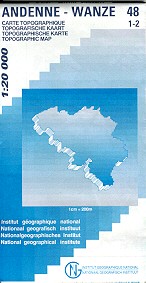
- Andenne - Wanze
- Topographical survey of Belgium at 1:20,000 from Nationaal Geografisch Instituut / Institut Géographique National, the country’s national survey organization. Each 20K map covers one quarter of the corresponding 1:50,000 map (with adjustments in the border and coastal areas). The maps provide all the information expected of topographic mapping... Read more

Stanfords
United Kingdom
United Kingdom
- Geological Map of the World Wall Map
- This new edition (August 2014) reconsiders the 3rd edition of the Geological Map of the Word, published initially in 2010 at the scales of 1:25 000 000 (3 sheets) and 1:50 000 000 (1 sheet Geology, structure), both presently out of print.The layout of this new version, centered on the Atlantic, was redesigned in order to fit a single sheet,... Read more

Stanfords
United Kingdom
United Kingdom
- Odeigne - Bihain
- Topographical survey of Belgium at 1:20,000 from Nationaal Geografisch Instituut / Institut Géographique National, the country’s national survey organization. Each 20K map covers one quarter of the corresponding 1:50,000 map (with adjustments in the border and coastal areas). The maps provide all the information expected of topographic mapping... Read more

Stanfords
United Kingdom
United Kingdom
- World Global Mapping Magnetic Fridge Map
- One of our best-selling maps of the world is now available to stick on your fridge, or any other magnetic surface.At a scale of 1:100,000,000 this wonderful fridge magnet measures 25.5x41.5cm and is flexibly made to simply peel on and peel off whenever you wish to display it.Bright, colourful and informative, this quirky magnetic World map... Read more

Stanfords
United Kingdom
United Kingdom
- Vielsalm - Recht
- Topographical survey of Belgium at 1:20,000 from Nationaal Geografisch Instituut / Institut Géographique National, the country’s national survey organization. Each 20K map covers one quarter of the corresponding 1:50,000 map (with adjustments in the border and coastal areas). The maps provide all the information expected of topographic mapping... Read more
Stanfords
United Kingdom
United Kingdom
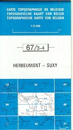
- Herbeumont - Suxy
- Topographical survey of Belgium at 1:20,000 from Nationaal Geografisch Instituut / Institut Géographique National, the country’s national survey organization. Each 20K map covers one quarter of the corresponding 1:50,000 map (with adjustments in the border and coastal areas). The maps provide all the information expected of topographic mapping... Read more
Stanfords
United Kingdom
United Kingdom
- Fleron - Verviers
- Topographical survey of Belgium at 1:20,000 from Nationaal Geografisch Instituut / Institut Géographique National, the country’s national survey organization. Each 20K map covers one quarter of the corresponding 1:50,000 map (with adjustments in the border and coastal areas). The maps provide all the information expected of topographic mapping... Read more

Stanfords
United Kingdom
United Kingdom
- Roeselare NGI Topo 19-20 - WWI Ypres Salient Battlefields
- Roeselare, map No. 19-20 in the topographic survey of Belgium at 1:50,000 covering the northern sector of the Ypres Salient battleground of World War I, north of the Paschendaele/Passendale – Boezinge line, including Steenstraat. Map legend includes English.Although not specifically designed to highlight locations connected with WWI, the map... Read more

Stanfords
United Kingdom
United Kingdom
- Mons NGI Topo 45 - WWI Battlefields
- Mons, map No. 45 in the topographic survey of Belgium at 1:50,000 covering the area of the Battle of Mons, British Army’s first major engagement in World War I in August 1914. The Mons - Condé Canal runs across the middle of the map and coverage includes Obourg where Private John Parr became the first British soldier to be killed in the war.... Read more

Stanfords
United Kingdom
United Kingdom
- Huy - Nandrin
- Topographical survey of Belgium at 1:20,000 from Nationaal Geografisch Instituut / Institut Géographique National, the country’s national survey organization. Each 20K map covers one quarter of the corresponding 1:50,000 map (with adjustments in the border and coastal areas). The maps provide all the information expected of topographic mapping... Read more

Stanfords
United Kingdom
United Kingdom
- Geological Map of the World FOLDED
- This new folded edition (August 2014) reconsiders the 3rd edition of the Geological Map of the Word, published initially in 2010 at the scales of 1:25 000 000 (3 sheets) and 1:50 000 000 (1 sheet Geology, structure), both presently out of print.The layout of this new version, centered on the Atlantic, was redesigned in order to fit a single... Read more

Stanfords
United Kingdom
United Kingdom
- Gouvy - Thommen
- Topographical survey of Belgium at 1:20,000 from Nationaal Geografisch Instituut / Institut Géographique National, the country’s national survey organization. Each 20K map covers one quarter of the corresponding 1:50,000 map (with adjustments in the border and coastal areas). The maps provide all the information expected of topographic mapping... Read more

Stanfords
United Kingdom
United Kingdom
- Dynamic World Global Mapping Wall Map ENCAPSULATED
- With this encapsulated 1:40,000,000 scale wall map of the world, learn how natural phenomena creates our dynamic planet.The cartography displays contours through detailed shadings for both land and bathymetric formations. The map features detailed descriptions of plate tectonics, earthquakes and tsunamis, volcanoes, hotspots and impact craters,... Read more

Stanfords
United Kingdom
United Kingdom
- Muno
- Topographical survey of Belgium at 1:20,000 from Nationaal Geografisch Instituut / Institut Géographique National, the country’s national survey organization. Each 20K map covers one quarter of the corresponding 1:50,000 map (with adjustments in the border and coastal areas). The maps provide all the information expected of topographic mapping... Read more